|
Overview
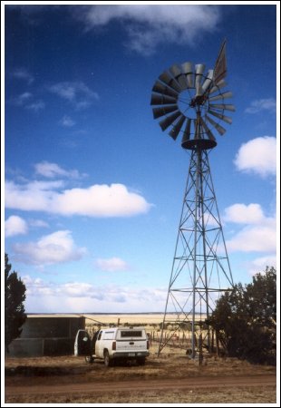
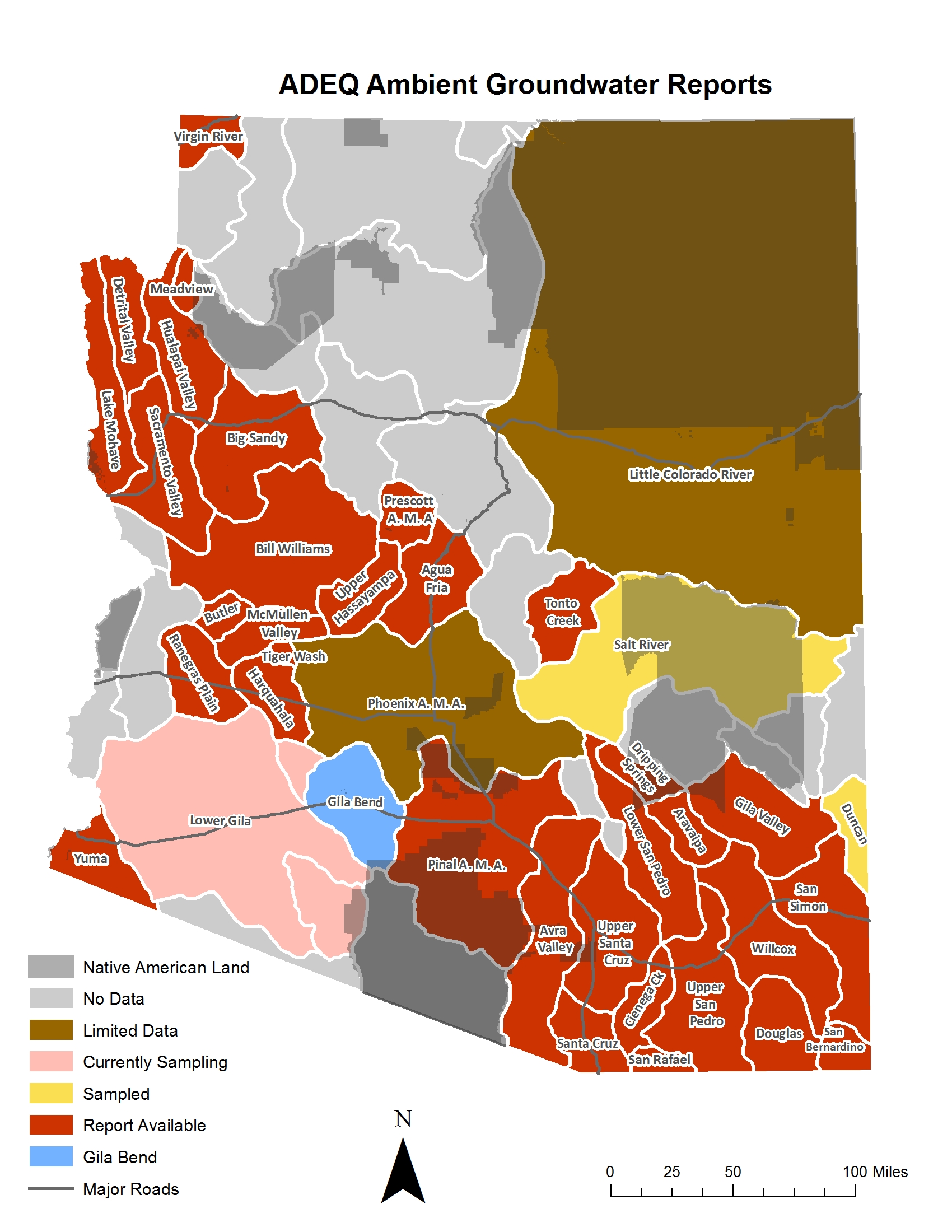
The groundwater monitoring program seeks to characterize groundwater quality in each of the 51 groundwater basins that have been designated in Arizona by state agencies. Comprehensive groundwater sampling is conducted in a basin following the approval of a sample plan. Various methodologies are used include systematic, grid-based random sampling, stratified random sampling, and random sampling to determine regional groundwater quality. Higher density sampling sometimes occurs around targeted land uses to determine their affect on groundwater quality. All wells and springs selected for sampling are located using a Global Positioning System (GPS).
Samples for Safe Drinking Water Act (SDWA) inorganic analysis as well as oxygen and hydrogen isotopes are collected at each groundwater sampling site. Samples for radiochemistry and radon analysis are also frequently collected while Volatile Organic Compounds (VOCs), currently-registered pesticides, banned pesticides, perchlorate, and other types of samples are sometimes collected where these parameters are likely to be encountered.
Groundwater samples collected for regional studies are analyzed to determine significant differences in parameter levels between indices such as sub-basins, physiographic areas, and aquifers. Similar analyses are conducted on data collected from index wells or from historical groundwater studies to determine if any significant changes have occurred over time in the concentrations of groundwater quality parameters.
Data collected by this program are incorporated into ADEQ's Groundwater Database and is provided to the well owner from which the sample was collected. A comprehensive Open File Report and a condensed four-page Fact Sheet are published for each basin. Index wells are selected in these basins which will be resampled in the future to determine groundwater quality changes over time.
These ADEQ basin studies are an important resource especially with many people moving to locations in Arizona not served by public water systems. Residents utilizing groundwater supplied by public water supply systems have the assurance that this resource is regularly tested and meets water quality standards set by the SDWA. However, no such regulations exist for residents served by private wells. While collecting and analyzing groundwater samples from all private wells would be prohibitively expensive, ambient groundwater quality studies that use scientific and statistical principles to estimate groundwater quality conditions provide an affordable alternative. As such, this program provides important groundwater quality information to the public, including the expected groundwater quality within a basin, areas where specific groundwater quality problems can be expected to occur, and whether there has been any change over time in the groundwater quality of the basin.
Studies
The ADEQ Ambient Monitoring Program has completed reports covering 20 groundwater basins within Arizona. These reports are available in two formats: a comprehensive Open File Report (OFR) and a compact four-page fact sheet (FS). The OFR is designed for audiences seeking an indepth hydrologic analysis of the basin. In contrast, the FS is designed for a more general audience seeking a brief overview of the groundwater quality of the basin.
The data for all samples collected for these studies, besides being available in the individual OFRs are also available through the ADEQ Groundwater Database. This database includes all samples collected by the ADEQ Ambient Groundwater Monitoring Program as well as other monitoring programs within the agency.
|
Groundwater Basin Fact Sheets
- Agua Fria Basin (2004-2006) -- (PDF)
- Aravaipa Canyon Basin (2003) -- (PDF)
- Avra Valley Sub-Basin (1998-2001) -- (PDF)
- Big Sandy Basin (2003-2004) -- (PDF)
- Bill Williams Basin (2003-2009) -- (PDF)
- Butler Valley Basin (2008-2012) -- (PDF)
- Cienega Creek Basin (2000-2001) -- (PDF)
- Detrital Valley Basin (2002) -- (PDF)
- Douglas Basin (1995-1996) -- (PDF)
- Dripping Springs Wash Basin (2004-2005) -- (PDF)
- Gila Bend Basin(2012-2015) -- (PDF)
- Gila Valley Sub-Basin (2004) -- (PDF)
- Harquahala Basin (2009-2014) -- (PDF)
- Hualapai Valley Basin (2000) -- (PDF)
- Lake Mohave Basin (2003) -- (PDF)
- Lower San Pedro Basin (2000) -- (PDF)
- McMullen Valley Basin (2008-2009) -- (PDF)
- Meadview Basin (2000-2003) -- (PDF)
- Pinal Active Management Area (2005-2006) -- (PDF)
- Prescott Active Management Area (1997-1998) -- (PDF)
- Ranegras Plain Basin (2008-2011) -- (PDF)
- Sacramento Valley Groundwater Basin (1999) -- (PDF)
- San Bernardino Valley Basin (2002) -- (PDF)
- San Rafael Basin (2002) -- (PDF)
- San Simon Sub-Basin (2002) -- (PDF)
- Sierra Vista Basin (1996) (in conjunction with the USGS) -- (PDF)
- Tiger Wash Basin (2014) -- (PDF)
- Tonto Creek (2002-2012) -- (PDF)
- Upper Hassayampa Basin (2003-2009) -- (PDF)
- Virgin River Basin (1997) -- (PDF)
- Willcox Basin (1999) -- (PDF)
- Yuma Basin (1995) -- (PDF)
Groundwater Open File Reports
- Groundwater Quality in Arizona: A 15-Year Overview of the ADEQ Ambient Monitoring Program (1995-2009) -- (PDF)
- Agua Fria Basin (2004-2006) -- (PDF)
- Aravaipa Canyon Basin (2003) -- (PDF)
- Avra Valley Sub-Basin (1998-2001) -- (PDF)
- Big Sandy Basin (2003-2004) -- (PDF)
- Bill Williams Basin (2003-2009) -- (PDF)
- Butler Valley Basin (2008-2012) -- (PDF)
- Cienega Creek Basin (2000-2001) -- (PDF)
- Detrital Valley Basin (2002) -- (PDF)
- Douglas Basin (1995-1996) -- (PDF) (Download PDF Maps)
- Dripping Springs Wash Basin (2004-2005) -- (PDF)
- Fort Valley Septic Study (1997) -- (PDF)
- Gila Bend Basin (2012-2015) -- (PDF)
- Gila Valley Sub-Basin (2004) -- (PDF)
- Harquahala Basin (2009-2014) -- (PDF)
- Hualapai Valley Basin (2000) -- (PDF)
- Lake Mohave Basin (2003) -- (PDF)
- Lower San Pedro Basin (2000) -- (PDF)
- McMullen Valley Basin (2008-2009) -- (PDF)
- Meadview Basin (2000-2003) -- (PDF)
- Pinal Active Management Area (2005-2006) -- (PDF)
- Prescott Active Management Area (1997-1998) -- (PDF)
- Ranegras Plain Basin (2008-2011) -- (PDF)
- Sacramento Valley Basin (1999) -- (PDF)
- San Bernardino Valley Basin (2002) -- (PDF)
- San Rafael Basin (2002) -- (PDF)
- San Simon Sub-Basin (2002) -- (PDF)
- Sierra Vista Sub-basin/Upper San Pedro Basin (1996-1997) -- (PDF)
- Tiger Wash Basin (2014) -- (PDF)
- Tonto Creek (2002-2012) -- (PDF)
- Upper Hassayampa Basin (2003-2009) -- (PDF)
- Upper Santa Cruz Basin (1998) -- (PDF)
- Virgin River Basin (1997) -- (PDF)
- Willcox Basin (1999) -- (PDF)
- Yuma Basin (1995) -- (PDF)
|
|

Back
|