General Overview
The Surface Water Section (SWS) is responsible for implementing ADEQ surface water quality monitoring programs. ADEQ staff collect water quality data to assess the biological, chemical, and physical integrity of Arizona's rivers and streams. The general purposes of the ambient monitoring program are to:
- Collect data to determine current water quality conditions;
- Provide data to support water quality assessments;
- Determine compliance with applicable surface water quality standards; and
- Provide data to support the development of new or revised water quality standards.
The information collected is used to produce biennial water quality assessment reports which describe water quality conditions across Arizona and identify surface water impairments (see Assessments). A surface water is deemed to have impaired water quality if the chemical, biological, or physical integrity of the water does not meet one of the surface water's intended uses (i.e. fishing, swimming, domestic water, etc.). Once a surface water is deemed to be impaired, an intensive survey of pollutants and sources in the watershed is conducted by the Total Maximum Daily Load (TMDL) Program. For more information regarding impaired waters see the TMDL Program.
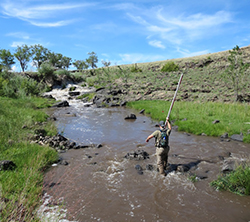
Water Quality Monitoring
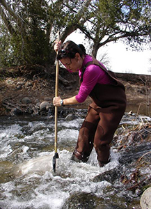
Currently, ADEQ is employing a targeted approach to address water quality for wadeable, perennial streams. Most sites are sampled quarterly for chemical constituents and annually for macroinvertebrate and physical habitat data. Targeted sites are selected for one or more of the following reasons:
- Data gaps - More data is required to address the status of a water body in relation to the surface water quality standards for the 305 (b) assessments.
- Never been sampled - Wadeable, perennial streams where data has never been collected.
- Outstanding Waters – Continual samples are collected on one or more of Arizona’s 22 Outstanding Arizona Waters for trend analysis purposes.
- Biocriteria Reference Sites – Benthic macroinvertebrates are collected in streams during the spring index period to collect current and relevant data.
- Special Studies – Monitor impacts on water bodies for various reasons including wildfires, high human use areas, or effluent dominated water.
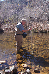
Field Measurements Include:
- pH
- Total Dissolved Solids
- Dissolved Oxygen Concentration
- Dissolved Oxygen Percent Saturation
- Air and Water Temperature
- Specific Conductivity
- Turbidity
- Discharge
- Bacteria Concentrations
Water Samples are analyzed for:
- General Chemistry
- Major Cations and Anions
- Nutrient Concentrations
- Total Metal Concentrations
- Dissolved Metal Concentrations
- Suspended Sediment
Back to the top of the page
Methods
Reports
Back to the top of the page
Bioassessment
The Bioassessment Program conducts biological monitoring and assessment activities to determine the biological integrity of a surface water. Biological integrity can be defined as the capability of a surface water in supporting and maintaining a balanced, integrated, adaptive community of organisms having a species composition, diversity and functional organization comparable to that of the natural habitat of the region.
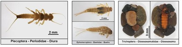
This is done by collecting aquatic macroinvertebrates within a wadeable, perennial stream during the spring months of April through June. Aquatic macroinvertebrates are animals without back bones that live in aquatic environments and are large enough to be seen without a microscope or other magnification.
Macroinvertebrate sampling helps determine the health of a stream by looking at species richness (number of species), composition, tolerance levels (i.e., sensitive or tolerant to pollution), and the feeding strategies of the species present.
Back to the top of the page
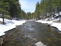
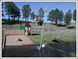
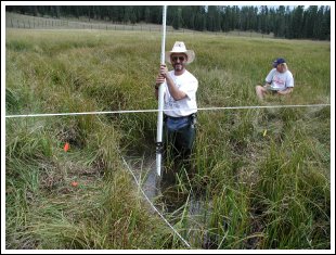 Physical Integrity
Physical integrity in streams is the dynamic balance of stream stability over time. Through measurements and assessment of the streams dimension, pattern, and profile physical integrity is determined. Naturally stable streams, those with physical integrity, can be described as having a dynamic balance between erosion and deposition.
Many of Arizona's streams and rivers have significant problems due to sediment imbalance. Excess sediments can fill lakes and reservoirs, negatively affect aquatic organisms, and act as a carrying agent for pollutants including phosphorus, nitrogen, metals, and agricultural chemicals.
To initiate development of meaningful physical integrity criteria ADEQ is performing geomorphic surveys on streams. This research has focused on:
- Developing regional curves to estimate bankfull. Bankfull is the point at which water flows out of the channel over the bank and into the floodplain.
- Testing Rosgen's (1996) Bank Erodibility Hazard index (BEHI).
- Creating sediment rating curves to evaluate excess sediment loads verses impacted streams.
- Investigating the feasibility of narrative physical integrity criteria for Arizona's rivers and streams.
- Making screening level field assessments of vulnerable stream reaches in each watershed/basin.
For more information, please visit Wildland Hydrology  . .
Back to the top of the page
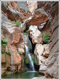
ADEQ/USGS Cooperative Monitoring
Starting in 1987, ADEQ and the U.S. Geological Survey (USGS) entered a cooperative agreement that contracts the USGS to monitor Arizona's larger rivers. These rivers include the Colorado River, Salt River, Gila River, Verde River, and the Bill Williams River. The USGS obtains quarterly chemical integrity monitoring on 10 sites located on these rivers. The results are published in the USGS annual water resource data report for Arizona and are also available online through the USGS website (see link below for the chemistry results).
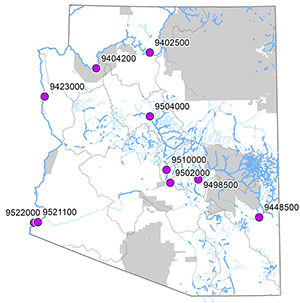
| ADEQ ID |
USGS No. |
Site Name |
New/Exisiting? |
Schedule |
| CLCLR023.30 |
09522000 |
Colorado River-Above Morelos Dam | Existing | All |
| UGGLR448.61 | 09448500 | Gila River-At Head of Safford Valley | Existing | All |
| CLCLR048.36 | 09429490 | Colorado River-Above Imperial Dam | Existing | Even |
| SRSLR051.32 | 09502000 | Salt River-Below Stewart Mountain Dam | Exisiting | All |
| SRSLR107.43 | 09498500 | Salt River-Above Lake Roosevelt | Existing | All |
| VRVER022.53 | 09510000 | Verde River-Below Bartlett Dam | Existing | All |
| VRVER053.21 | 09508500 | Verde River-Below Tangle Creek | Existing | Even |
| CLCLR195.22 | 09427520 | Colorado River-Below Parker Dam | Existing | Even |
| VRVER150.65 | 09504000 | Verde River-Near Clarkdale, AZ | Existing | All |
| CGCLR698.93 | 09380000 | Colorado River-At Lees Ferry, AZ | Existing | Even |
| CGCLR610.88 | 09402500 | Colorado River-Near Grand Canyon | New | Odd |
| CGCLR473.00 | 09404200 | Colorado River-Above Diamond Creek Near Perch Springs | New | Odd |
| CLCLR279.46 | 09423000 | Colorado River-Below Davis Dam | New | Odd |
| CLCLR029.59 | 09521100 | Colorado River-Below Yuma Main Canal | New | Odd |
| See Also:
Back to the top of the page
Back |
|